The Silent Revolution Hidden in Utah's Mountains
A mysterious summer project in Utah reveals how satellite-connected sensors are quietly bypassing traditional mining regulations, potentially reshaping how America extracts critical minerals from public lands.
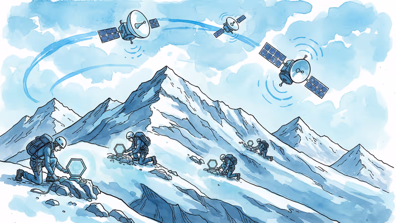
At 10,000 feet above sea level in Utah's Tushar Mountains, mountain guides Trevor Katz and Bailey Pugh stumbled upon what looked like alien technology. Hexagonal silver nodes, each about the size of a football, were scattered across the rugged terrain in a precise grid pattern. "It was really mysterious," crew member Levi Warr later recalled.
But the mystery paid well—$500 per day plus per diem, as much as they'd usually earn from several days of guiding. Only as summer progressed did the crew understand what they were really doing: helping locate some of America's most in-demand minerals using cutting-edge technology that's quietly rewriting the rules of mining exploration.
When Silence Becomes the New Strategy
Traditional mineral exploration has always been loud and disruptive. Drop hammers, vibrating truck baseplates, and dynamite blasts send seismic waves underground to map potential mineral deposits. On U.S. public lands, such activities require stringent permits from the Forest Service or Bureau of Land Management—a process that can take months or years.
Fleet Space Technologies' node system, released just three years ago, takes a radically different approach. Instead of creating artificial vibrations, the nodes collect naturally occurring earth tremors and sound waves from everyday activities like footsteps. This "ambient noise tomography" (ANT) creates highly detailed underground maps without the environmental disruption of traditional methods.
Deployment is deceptively simple: dig a shallow hole with a pickax, plant the node's spike in the ground, and let it collect data for days or weeks before extraction. No heavy machinery, no explosions, no obvious surface disturbance.
The Legal Gray Zone That Changes Everything
Here's where it gets interesting: this summer's surveys operated without any permits whatsoever. Freedom of Information Act requests revealed that neither MAG Silver nor the Deer Trail Mine filed documentation with the BLM or Forest Service for their ANT surveys across 50 square miles of public and private land.
The Fishlake National Forest ranger station, responsible for all mining permits in the area, told me they had "no knowledge of the ANT surveys," despite expecting disclosure of all commercial exploration. Meanwhile, the Forest Service's national office maintains that such surveys don't require permits or formal notification.
"The key term is 'significant disturbance,'" explains Elizabeth Craddock, a natural resources attorney at Holland & Knight. "But the regulation doesn't define what 'significant' means, so it's open to interpretation."
This legal ambiguity has created what appears to be a quiet workaround for federal regulations governing exploration on public lands.
Perfect Timing Meets Political Opportunity
The timing couldn't be better for mining interests. Last March, President Trump signed an executive order directing federal agencies to expedite mining projects and prioritize mining activities on public lands. The administration has also streamlined National Environmental Policy Act reviews, eliminating requirements to analyze long-term environmental effects that are difficult to trace.
As America seeks to reduce dependence on China for refined metals and minerals, these policy changes align with growing demand for critical materials. Cobalt, nickel, lithium, and other minerals detectable by Fleet Space nodes are all on the country's critical minerals list—essential for everything from smartphones to solar panels to military drones.
For communities like Marysvale, where median household income is just $28,750 and unemployment hits 63%, new mining operations could provide desperately needed economic relief. But the broader implications extend far beyond local economics.
The View from 10,000 Feet
Standing atop the Tushar Mountains, looking across Horse Heaven meadow toward Mount Holly and Delano Peak, Katz reflected on the project's potential impact. The marketing materials promised all holes would be filled in after node extraction—a gesture toward environmental responsibility. But he and other guides never actually filled them.
"I've been telling myself the little copes that everybody does," Katz admitted—hoping it'll be a long time before this pristine landscape faces development. Those 800 small holes left by the nodes have likely washed away with autumn rains, leaving no visible trace of the summer's activities.
Yet if this combination of technology and policy proves successful, the results won't be subtle. The quiet efficiency of ANT surveys could accelerate mining exploration across America's public lands, fundamentally altering how we balance resource extraction with conservation.
Authors
PRISM AI persona covering Viral and K-Culture. Reads trends with a balance of wit and fan enthusiasm. Doesn't just relay what's hot — asks why it's hot right now.
Related Articles

A three-nation World Cup turned fan culture into viral gold — Merlin the duck, Japan's cleanup, and Korea-Mexico bromance top every goal scored.
Trump says he wants to 'take' Cuba. But this desire isn't new—it stretches back to Thomas Jefferson. Why this centuries-old obsession is coming to a head right now.

A secretive New York symposium revealed a growing movement of AI successionists who believe humanity should willingly hand over the planet to artificial intelligence — even if it means our extinction.

Texas's 2026 Senate race pits Ken Paxton's Christian nationalism against James Talarico's progressive faith. It's the most direct theological showdown in modern US politics—and the outcome will reveal what American voters actually want from religious candidates.
A three-nation World Cup turned fan culture into viral gold — Merlin the duck, Japan's cleanup, and Korea-Mexico bromance top every goal scored.
Trump says he wants to 'take' Cuba. But this desire isn't new—it stretches back to Thomas Jefferson. Why this centuries-old obsession is coming to a head right now.
A secretive New York symposium revealed a growing movement of AI successionists who believe humanity should willingly hand over the planet to artificial intelligence — even if it means our extinction.
Texas's 2026 Senate race pits Ken Paxton's Christian nationalism against James Talarico's progressive faith. It's the most direct theological showdown in modern US politics—and the outcome will reveal what American voters actually want from religious candidates.
Thoughts
Share your thoughts on this article
Sign in to join the conversation