A Line on a Map: Why Cambodia and Thailand Are Back at War
In December 2025, the Cambodia-Thailand border conflict has reignited, shattering a recent peace deal. Explore the 100-year-old dispute rooted in a French colonial map, the 1962 ICJ ruling, and why diplomacy failed.
A peace deal hailed just two months ago has collapsed into heavy fighting. In December 2025, hostilities between Cambodia and Thailand erupted anew along their disputed border, displacing over 750,000 people and shattering a U.S.-brokered accord. The conflict's origins lie not in recent tensions, but in a century-old map drawn by French colonial cartographers.
The recent flare-up began in July 2025 with firefights across the border. A U.S.-mediated ceasefire on July 28 briefly paused the violence. Working with ASEAN, President Donald Trump then helped broker the Kuala Lumpur Peace Accord on October 26, which aimed to turn the fragile truce into a long-term de-escalation framework. Both countries agreed to a phased withdrawal of heavy weaponry.
But the accord never attempted to confront the territorial dispute at the center of the conflict. In retrospect, its failure was probably inevitable.
---
## Timeline: From Peace Accord to Open Conflict
* **July 28, 2025:** After initial firefights erupt, the United States mediates a ceasefire.
* **October 26, 2025:** The Kuala Lumpur Peace Accord is signed in Malaysia, witnessed by U.S. President Donald Trump and Malaysian Prime Minister Anwar Ibrahim.
* **Early November 2025:** Several Thai soldiers are injured by a landmine. Bangkok claims it was newly planted by Cambodia and suspends its obligations under the peace deal. Phnom Penh denies the claim.
* **December 7, 2025:** Following a new incident, the two sides exchange heavy fire once again, effectively rendering the peace framework defunct.
---
## callout-info: Background: The Colonial Seed
The dispute dates to the early 20th century, when Cambodia was part of French Indochina. France, seeking to secure its colonial borders, and Siam (modern-day Thailand), struggling to preserve its independence, negotiated a new boundary. A 1904 treaty established the "watershed principle"—the crest of the Dangrek Mountains—as the natural dividing line. However, the critical work of surveying and map-making was left to a joint Franco-Siamese commission, which was dominated by French technical officers.
This commission produced a series of maps, including the one now known as the Annex I Map. This map covered the Preah Vihear temple, an 11th-century Angkorian ruin. Had the watershed principle been strictly applied, the temple would have been on the Siamese side. The French-drawn map, however, placed it in Cambodia.
Crucially, when Siamese officials received the map around 1908, they lodged no formal protest. In international law, a state's silence in the face of such a delineation can be interpreted as tacit acceptance, or acquiescence. For decades, the map was used without objection in official documents and even school classrooms.
Everything changed after Cambodia gained independence in 1953. With the colonial framework gone, Bangkok reopened the border question, arguing the map violated the 1904 treaty's watershed principle. In 1954, Thai troops occupied the temple.
In 1959, Cambodia took the case to the International Court of Justice (ICJ). In its landmark 1962 ruling, the ICJ found that Thailand had accepted the Annex I Map for half a century through its actions and silence. Its late-stage objection could not override decades of acquiescence. The court held that Preah Vihear temple belonged to Cambodia.
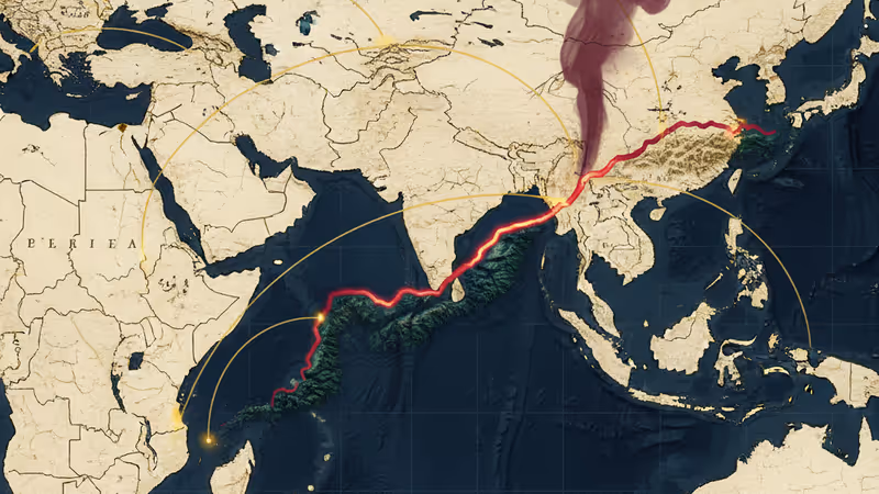
Yet, the ICJ's ruling never adjudicated the entire 817-kilometer frontier. It left large stretches of land, including other ancient temples like Ta Moan Thom, Ta Moan Tauch, and Ta Krabei, undefined and vulnerable to competing claims. These areas are the flashpoints of the 2025 conflict.
Thailand argues that the treaty-mandated watershed line places these other sites on its side and that other French maps lack binding force without clear joint approval. Cambodia counters that all the maps were produced under treaty authority and implicitly accepted by Siam over time, a pattern of behavior the ICJ itself recognized.
## PRISM Insight: Colonial Legacies and the Limits of Diplomacy
The Cambodia-Thailand conflict is a textbook case of how ambiguous colonial-era legacies can erupt into 21st-century violence. It highlights a classic international law dilemma: which holds more weight, the text of a treaty (the watershed principle) or subsequent state practice (the acceptance of a map)? The rapid collapse of the October peace accord also demonstrates the limits of third-party mediation, such as that led by the Trump administration, when it fails to confront the core territorial dispute. A map, this conflict shows, is never just a map; it's a battleground for history, sovereignty, and national identity.
本内容由AI根据原文进行摘要和分析。我们力求准确,但可能存在错误,建议核实原文。
相关文章
前總統川普的著名批評者、保守派律師喬治・康威,正式登記以民主黨員身份競選國會議員。這位「林肯計畫」共同創辦人的參選,為紐約的激烈初選投下變數,也象徵「永不川普」運動的重大轉向。

美國內政部以未明的「國家安全風險」為由,宣布限制離岸風電項目發展。此舉引發業界強烈反彈,批評政府意在打壓綠色能源,為化石燃料鋪路。

報導指控沙烏地阿拉伯可能購買了由俄羅斯從烏克蘭佔領區竊取的穀物。本文深入分析此事件對全球糧食安全、地緣政治及供應鏈倫理帶來的複雜影響。

美國扣押委內瑞拉油輪,引發「制裁執法」與「海盜行為」的激烈爭論。本文深入剖析美委雙方理據、國際法的模糊地帶,以及此舉對全球能源安全與地緣政治格局的深遠影響。